New Delhi: One winter morning in 2020, Amichand (who gave us only his first name) watched, a little nonplussed, as a drone flew over Akbarpur Nangal village of Kanina block in Mahendragarh, Haryana.
Two weeks later, when officials arrived at his doorstep to verify house ownership details plotted on an aerial map drafted after the drone flights, Amichand wasn’t home.
The 56-year-old farmer would find out only weeks later that his home was now marked in village property records as being owned by his son, who claimed the house as his during door-to-door visits by officials.
“I am told that my son claimed my house,” Amichand told Article 14. “I want it to be registered in my name instead.”
When Prime Minister Narendra Modi said in his Independence Day speech in August 2021 that drones were helping rural citizens map their lands and apply for various schemes and loans, he was referring to the Svamitva Yojana, a union government scheme to provide land titles to homeowners in India’s villages.
Modi claimed that Svamitva would end property disputes in rural India. But more than a year since its launch, a closer look at the implementation of the scheme shows a different ground reality. For hundreds of people like Amichand, the scheme has started new struggles to prove ownership of a home they have lived in for years.
In Haryana—which has made the most progress under the scheme—technical errors caused by drone imagery created newer property disputes among villagers. Public hearings, crucial to determine rightful owners of properties, were rarely held due to Covid-19 restrictions. Village panchayats instead resorted to door-to-door meetings with home occupants to finalise property details, defeating the purpose of a public meeting and violating the scheme guidelines.
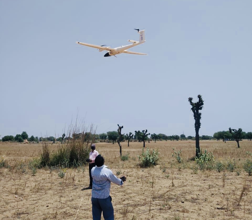
Drone Imagery For Village Property Titles
Residential areas of villages in India have never before been surveyed, and home owners have no formal land records. Svamitva, acronym for Survey of Villages Abadi and Mapping with Improvised Technology in Village Areas, aims to fill this gap through a nationwide programme based on drone imagery.
Under the project, drone surveys replace time-consuming physical measurement of properties, thus speeding up the survey process at lower costs.
Modi launched the scheme in April 2020, barely a month after his government imposed a strict nationwide lockdown to contain the COVID-19 pandemic.
In the months that followed, drones flew over residential areas in 101,000 pilot villages, capturing photos and geographical data. Based on that, state officials and village panchayats prepared maps and draft records identifying who owns which house. The programme is now in operation in 26 states.
A year after the launch, in April 2021, drone surveys were completed in 44,000 villages, but property cards were distributed in only about 7,489 villages.
The village and district level officials tasked with implementing the scheme are only able to grant land titles or property cards to owners whose properties are correctly captured by the drones, leaving others to go through time-consuming processes to make corrections to drone data or approach district revenue authorities or civil courts, which are already clogged with cases.
Even people with the Svamitva property cards are finding it difficult to avail loans as neither the Reserve Bank of India nor state governments have framed guidelines for banks to lend against the cards.
Maps Mired In Image Disputes
Between May and October 2020, “despite the pandemic, there was a haste from district authorities for implementing the scheme in our village”, said 60-year old Ram Kishan, who was, until February 2021, the sarpanch of Bairawas, a village surrounded by bajra fields in Haryana’s Mahendragarh district.
As the sarpanch, Kishan followed the directions of the district revenue authorities and began explaining the scheme to village residents.
The Svamitva scheme functions on guidelines issued by the Ministry of Panchayati Raj.
First, private drone operators map villages in collaboration with the union government’s Survey of India or SoI. The SoI processes the data within two weeks. After that, the state government and SoI present a village map with properties demarcated. They begin an enquiry process: property claims and disputes are recorded in the presence of officials and villagers at a public meeting. This has to be completed within another four weeks. Finally, ownership cards are issued.
At Bairawas, drone flights were conducted over two days in September 2020. Revenue department and gram panchayat officials then displayed the village map prepared by SOI in the panchayat office, and residents were asked to file their claims and objections.
“That was a complicated process for various reasons such as there was the fear of contracting to COVID-19, social distancing protocols were in place and many property owners were not present in the village at the time,” said Kishan.
He added that apart from the earlier existing property-related disputes between co-owners and family members, new kinds of disputes started emerging in the village due to the feature identification numbers allotted to the houses or plots in the SoI map.
There were cases of one ID allotted to a property claimed by more than one person. There were errors in the boundaries with one person’s land marked as part of another’s. This required boundaries of the property to be redrawn and creation of a new map or a new set of IDs, Kishan said.
Each change to the maps requires panchayat officials to travel 300 km to the SoI’s regional center in Chandigarh, said Karan Singh, a panchayat secretary in the district.
“Only those people whose properties are perfectly demarcated in the final maps and without any disputes have obtained the ownership titles to their properties so far,” Singh said.
In February 2021, village panchayats in Haryana came to the end of their five-year term. But with the state government delaying elections to panchayats, elected representatives like Kishan are out of power, and their tasks under Svamitva delegated to panchayat secretaries like Singh, who are state government employees.
Covid Halts Public Meetings
In December 2020, authorities conducted drone sorties over Akbarpur Nangal (Nangal Harnath) village of Kanina block in Mahendragarh. Two weeks after the drone survey, the village residents said, the sarpanch and gram panchayat officials visited each house and showed residents the village map with demarcated boundaries of houses and plots.
No public meeting was held, a clear violation of the programme’s guidelines.
Rawat Singh, 75, and his family said they were “shocked” to find Singh’s name not mentioned as the owner of a plot he owns. Singh co-owned a property in Akbarpur Nangal along with his brothers. Five years ago, his brothers sold the property without his consent.
The Svamitva survey identified the property as belonging to the purchaser. Singh’s 40-year old son Sanjeev Yadav said they raised an objection against the plot being listed as belonging to the purchaser. “There was no progress after that. No public hearing was conducted.” .
There are many such cases in the village, said Yadav. He had submitted a written complaint to the block development officer, but eight months later he had not heard back.
Amichand, quoted earlier, said he was not present at the time of the door-to door-enquiry.
“The Haryana government has taken drone flying as the main priority,” said Rajendra Singh, who was sarpanch of Akbarpur Nangal village when the surveys happened. Singh said the enquiry and the ground truthing processes were being conducted “in such a way that most of the disputes remain pending”.
No Dispute Resolution Mechanism At Local Level
Revenue department officials visit the villages during the enquiry process, until the village map is finalised. After that, for any kind of disputes, village residents must approach revenue authorities or civil courts.
In some kinds of disputes, physical measurements must be conducted. There are even disputes on ownership of houses for which property cards are already distributed.
Singh said that he is certain that the disputes will continue to exist for years and it is an “endless process” as there is no permanent dispute redressal mechanism at the panchayat level.
At Bairawas village, the map has been changed three times so far, said Kishan, the former sarpanch. Many disputes are still unresolved and out of the approximately 700 houses in the village, only 231 ownership cards had been distributed in mid-August 2021.
If only a small percentage of a village’s residents could receive the property cards, the government must re-examine the entire record preparation process, said Deepak Sanan, a former Indian Administrative Services (IAS) officer and senior advisor with non-profit economic policy research institute National Council of Applied Economic Research (NCAER).
The drone surveys have also outpaced the enquiry process on the ground, according to data from the Svamitva website. For example, drone surveys were conducted in 754 villages in Andhra Pradesh but the subsequent stages of the scheme were yet to be started (see table).
“What is emerging is that the drone surveys are being rushed without adequate preparatory work,” said Sanan. He said the newly created records should be posted online to enable verification in case of disputes. Revenue departments already have processes to deal with and address disputes and make corrections in the records, he said.
Implementation Of Svamitva In States
Data as on 23 August 2021 from Svamitva website
*= Number of property cards distributed in Maharashtra as on 29 July 2021 (Data from Ministry of Panchayat Raj statement in Lok Sabha)
Property disputes are to be addressed by the state government, said Alok Prem Nagar, joint secretary in the union ministry of panchayati raj, in an email response to a set of queries from Article 14.
“Several new states in the pilot phase have taken action to overcome this issue,” said Nagar. “I am not sure, but the dispute may arise if one of the scions has left the Abadi and set up house in the agricultural field. In that case, solutions have to be improvised based generally on consensus.”
In 2020, when the scheme was in the pilot phase, the ministry asked Property Rights Research Consortium (PRRC), a think tank on property rights, land governance and housing issues, to “collate expert opinion and inputs on a few specific questions” to help design the next phase.
In its November 2020 report, the PRRC recommended that a detailed grievance mechanism may help ensure resolution of disputes in a timely manner. Communities should be involved during the drone mapping stage itself and given access to primary-level data to facilitate verification through triangulation of data, the report said.
“This has been done in Maharashtra and Odisha, where residents were directly involved in boundary demarcation to ensure community buy-in,” the report said. However, the ministry’s new framework for the ongoing phase of the scheme did not include the suggestions.
Sarampally Mallareddy, a farmers’ leader and vice-president of the All India Kisan Sabha, a national farmers’ organisation, said the new scheme to grant land titles to properties on abadi lands “without any provision for setting up dispute redressal mechanisms at the local body levels” appeared unplanned and is being hastily implemented.
“This will only burden revenue courts and civil courts which are already overwhelmed with pending land disputes with revenue departments across the country,” said Mallareddy.
Before implementing Svamitva, the government could have considered establishing village-level dispute resolution mechanisms, like Nyaya Panchayats, which were proposed in 2009 by the panchayati raj ministry but shelved in 2017, said Mallareddy.
Still In Talks: Guidelines On Bank Loans
Meanwhile, banks are reported to have rejected loan applications against Svamitva property cards, saying they have not received instructions from the Reserve Bank of India.
On the status of acceptance of Svamitva property cards as collateral by banks, Nagar, the joint secretary, said this is a work in progress. He said the government has held discussions with the department of financial services, with the State Bank of India, NABARD and Punjab National Bank, and has conveyed to the states their observations (including charge on property, stamping geotags, provisioning the card under their law and registering the card/deed).
“The states are directly putting the agenda item to approve SVAMITVA property card as a mortgageable tool in their meeting with the State Level Banking Committee, chaired by the Chief Secretary,” said Nagar.
Kishan, the sarpanch of Bairawas, said villagers would be encouraged to settle disputes and register their properties if they start getting loans using the Svamitva cards.
“Just like villages are sensitised about the Svamitva scheme by gram panchayats, banks and bankers need to be sensitised on issuing loans or financial assistance to people taking the property cards as collateral,” said Kishan. “Otherwise, this will turn out to be another data collection exercise of the government.”
(Prudhviraj Rupavath is researcher, land and forest governance, at Land Conflict Watch, an independent network of researchers studying land conflicts, climate change and natural resource governance in India.)